
Combining historical precedent, Ukrainian innovation and data-enabled planning to protect people, restore land use and manage persistent contamination
Solitudinem faciunt, pacem appellant
They make a wasteland, and call it peace
Tacitus, Agricola, chapter 30
A discussion paper for senior UN mine action, donors and policy makers
By Paul Davies, Head of Desk, Mine Action, Human Security Solutions & Paul Heslop, Senior Mine Action Advisor, UN Resident Coordinator’s Office, Kyiv, Ukraine
MAIN MESSAGE
Ukraine does not need a clearance plan alone. It needs an outcome-led land strategy supported by mine action evidence, with human security as the central purpose. Technical tasking and planning decisions should be driven by the outcome being sought: reduced risk, protection from harm, restored power, viable farming, safe return, access to water, cultural and social use, economic production, environmental recovery, normalisation and post-conflict stabilisation. Full threat removal will sometimes be essential. In other places, the right answer may be partial land release, targeted clearance, access corridors, land- use control, compensation, substitute land, repurposing, or long-term residual-risk management.
The French Zone Rouge shows that a state can protect people through classification, land-use control, exclusion, prioritised clearance, public warning and permanent response capacity, rather than attempting to remove every item of explosive ordnance from every hectare. Ukraine now needs that same realism, adapted to active war conditions, modern mine action standards, Ukrainian recovery priorities, data-enabled planning and community-level risk reduction. The aim is not to process land through a technical threat- eradication pipeline. It is to support defensible future land-use decisions that protect people, reduce vulnerability, and achieve a reasonable and acceptable residual-risk end state for the intended use.
EXECUTIVE SUMMARY
The Zone Rouge in north-eastern France remains one of the clearest long-term examples of a state choosing risk management over total threat eradication. After the First World War, France did not promise full clearance of the most devastated areas. It classified land by damage and intended use, controlled or excluded people from the worst areas, reforested large parts, kept some areas as memorial landscapes, and built permanent public capacity to respond to explosive ordnance finds.
Ukraine makes this lesson urgent. Parts of the war have produced contamination unusually close to the industrial battlefields of the First World War: trenches, mine belts, artillery saturation, shattered settlements, repeated fighting over the same ground, extensive defensive works and deep uncertainty about future land use. Modern weapons, drones and data systems make Ukraine different from France in 1919, but the static, fortified and attritional character of much fighting, especially in the east and south, makes the Zone Rouge precedent highly relevant.
The policy question is not only how Ukraine can increase clearance capacity. It is how Ukraine, with donor and UN support, decides which land should be cleared now, which land can be released after survey, which land should remain controlled, which land should be repurposed, and which owners or communities may need compensation, substitute land or other support. This is a land-use, public-safety and human-security question as much as a technical clearance question.
The central shift should be from outputs to outcomes. Hectares cleared, items destroyed and contracts delivered matter, but they are not the final purpose. The purpose is to protect people, reduce vulnerability, restore access, enable essential services, support livelihoods, rebuild public confidence and help communities recover with dignity. Technical methods should therefore be selected according to the confidence level needed for the intended use, not by default movement toward full manual clearance of every suspected area.
This does not make economic value unimportant. NPV, discounted cash-flow and future land-use analysis can help decide whether commercial, infrastructure or alternative land uses justify targeted clearance. But the test must not become narrowly commercial. The overriding purpose of mine action remains human security: protecting people from harm, reducing vulnerability, enabling safe enough use with acceptable residual risk, and ensuring that the most exposed communities are not left waiting while lower- risk or higher-profile tasks absorb scarce resources.
Farmland illustrates the issue, but the argument is wider than agriculture. A family garden, a daily tractor route, a high-value orchard, a remote low-value plot in a former defensive belt, a transformer site, a firebreak, a cemetery, a forest path and a field next to a returning settlement should not automatically receive the same technical answer. In some cases, full clearance will be essential. In others, compensation, substitute land, targeted access clearance, fencing, marking, monitoring, repurposing, exclusion or deferred treatment may protect people faster and free scarce assets for higher-risk tasks.
The paper proposes a dynamic Ukraine classification model: red zones for long-term controlled or excluded land; orange zones for managed-risk or conditional use; green categories for land with no evidence of mines or explosive ordnance after different levels of assessment; white areas with no reason for suspicion; and blue overlays for public-priority corridors and essential services. The model is not a map of abandonment. It is a way to make honest decisions about intended future use, evidence, confidence, public value, exposure, vulnerability and residual risk.
Ukraine has already shown exceptional capacity for rapid wartime innovation, especially in drone and data- enabled systems; the same national strength should now be applied to mine action technology, land classification and outcome-led tasking.
Community Risk Reduction provides the community layer of this logic: Risk = Threat x Vulnerability. A serious Ukraine strategy must reduce the threat where clearance is necessary and reasonable, and reduce vulnerability where people can be protected sooner through safer routes, reporting systems, marking, fencing, livelihood support, compensation or controlled access. In the highest-risk areas, where vulnerability cannot be reasonably reduced, long-term exclusion may itself be the most responsible human- security outcome.
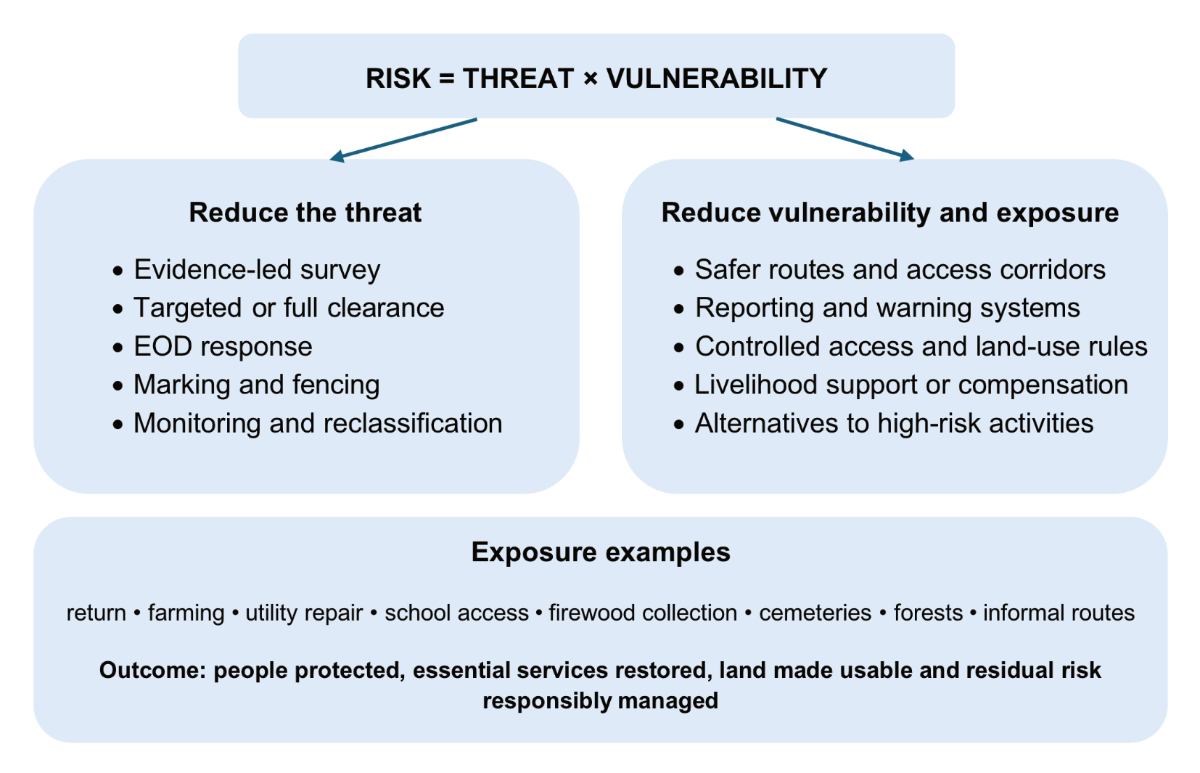
Figure 1. Community Risk Reduction: two levers, one human-security outcome
1. WHY THE FRANCE-UKRAINE COMPARISON IS APPROPRIATE
The comparison should be made carefully. Ukraine is not post-war France. The war is ongoing. The weapon mix is different. The legal environment is different. Ukraine has a modern economy, active frontlines, occupied territory, a national recovery agenda and a large international support architecture.
But the comparison remains one of the most useful historical precedents available. The strongest link is the character of the fighting. Much of the war in Ukraine, especially in the Donbas and parts of the south, has had a static, fortified and attritional character reminiscent of First World War battlefields: trench systems, layered defences, mine belts, repeated attacks over prepared positions and artillery saturation.
Static industrial warfare creates a different mine action problem from short, mobile battles or isolated minefields. It produces layered contamination: mines, unexploded artillery, rockets, cluster munition remnants, anti-vehicle mines, booby traps, abandoned ammunition, damaged military equipment, trenches, dugouts, scrap metal, human remains and destroyed infrastructure. It also creates areas where the intended future land use may be genuinely uncertain.
The point is not to say that Ukraine should abandon land. The point is to recognise that some land will need to be classified, controlled, sequenced, repurposed or compensated before it can be treated as a normal clearance task. The French precedent helps make this politically sayable.
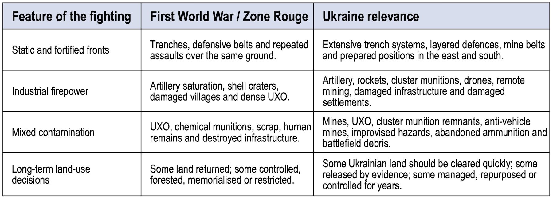
Table 1.
2. WHAT THE ZONE ROUGE TEACHES
The Zone Rouge was created after the First World War for areas considered too devastated for normal life and land use. Contemporary classifications separated areas by level of destruction and possibility of restoration. Over time, much land was cleared, reclassified and returned to civilian use. The worst areas were treated differently: the state kept or controlled land, accepted that normal use was not realistic, and allowed or planned reforestation and memorial use.
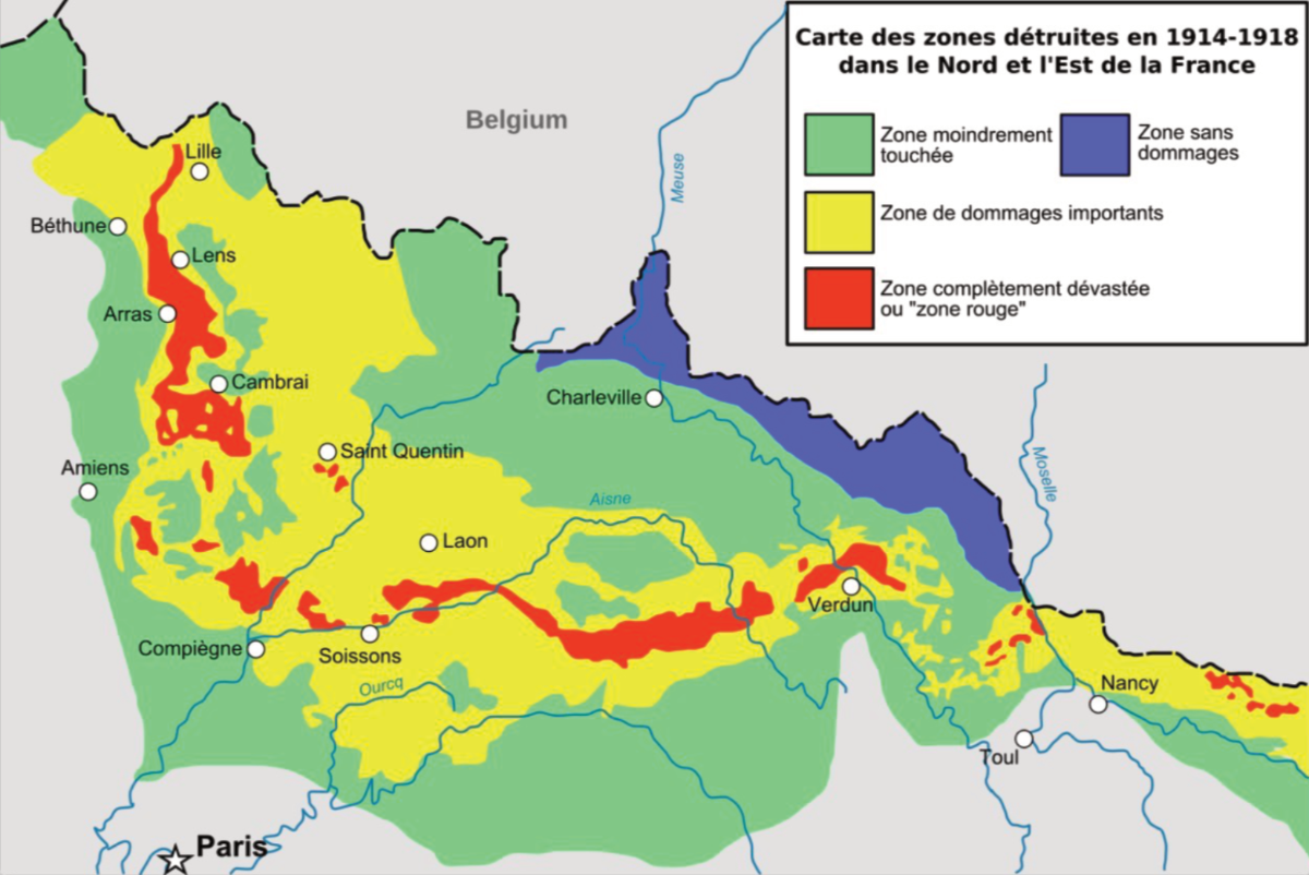
Figure 2: Post-First World War damage classification in north-eastern France: a useful precedent for separating land by damage, risk, restoration potential and future use.
The essential point is that France did not treat all contaminated land as equal. It did not say that every hectare must be cleared to the same end state before any public benefit could be allowed. It adopted a wider public safety model: classification, land-use control, restrictions, warnings, targeted clearance, public reporting and a permanent national response service.
The modern French system continues to manage explosive ordnance through a public safety service. Finds are handled by trained specialists. The system accepts that old munitions will continue to appear, and that the state must retain a standing capacity to respond. This is not a project with a final ribbon-cutting ceremony. It is a permanent function.
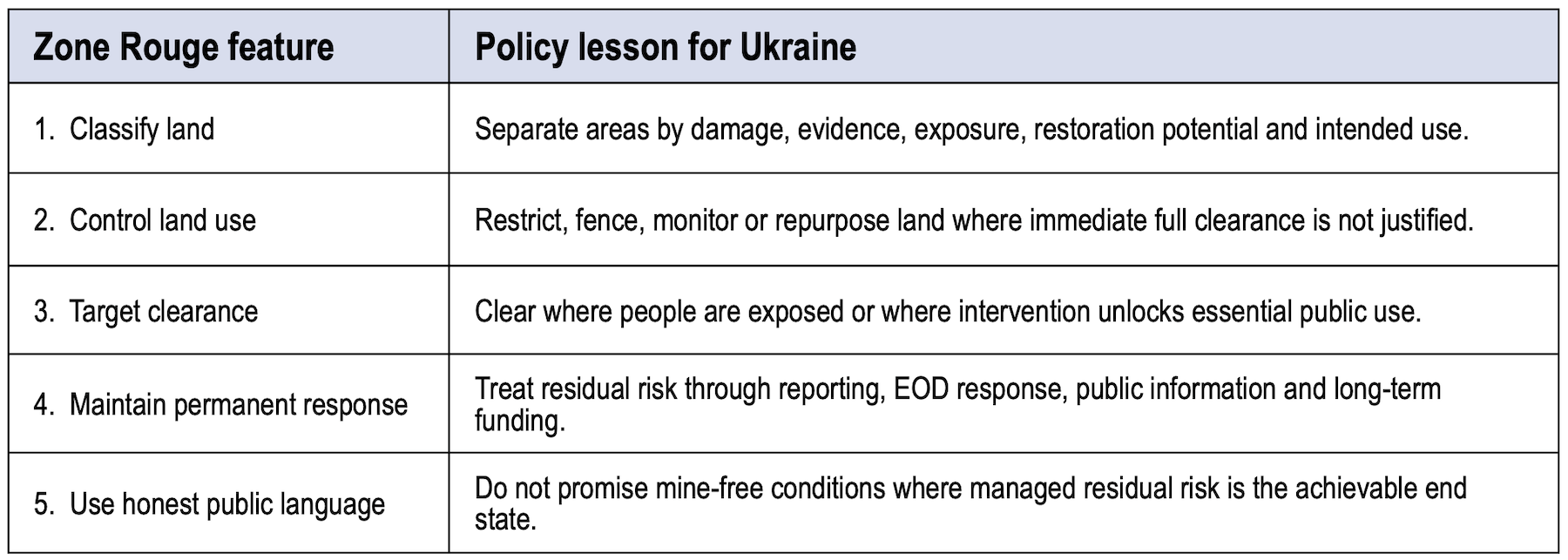
Table 2.
For Ukraine, the lesson is that the end state should be defined by intended land use and by the level of residual risk that is reasonable and acceptable for that use. A road, a school, a farm field, a forest, an industrial site, an electricity substation, a riverbank, a memorial area and a former trench belt do not all require the same confidence level, the same methods, the same timetable, or the same public investment.
The central policy shift is from clearance as an end in itself to mine action as an enabling process for future land use, human security and recovery. Technical mine action processes – non-technical survey, technical survey, clearance, marking, EORE, EOD response, quality assurance and handover – should not be treated as stand-alone outputs. They are means to protect people and enable outcomes.
Those outcomes may include restored electricity, access to water, safer return, viable farming, emergency access, public transport, school access, health service access, cultural and social use, environmental management, economic production, community confidence, normalisation and post-conflict stabilisation. In some cases, the outcome will require full clearance. In others, it may require only targeted clearance, access corridors, partial land release, land- use control, compensation, exclusion, repurposing, or a managed residual-risk arrangement.
The future land use may not be the same as the pre- war land use. A mined wheat field may become a solar site, a wind-energy project, a controlled buffer, a forestry zone, a memorial landscape, a conservation area, a container-based production site or a later clearance task. The technical question should therefore be: what evidence, confidence level and residual-risk controls are required for the intended future use?
Outcome-led principleMine action in Ukraine should support defensible land-use decisions. The question is not simply “what threat is present?” but “what outcome is being enabled, what confidence level is required, what residual risk is acceptable, and what is the least wasteful way to protect people and unlock public value?” |
3. UKRAINE’S PROBLEM IS NOT ONLY SCALE: IT IS EVIDENCE, EXPOSURE AND LAND USE
Ukraine’s contamination is often presented through very large numbers. Those numbers communicate scale, but they become dangerous if they are mistaken for an operational clearance plan. A national figure for suspected or potentially contaminated land is not the same as a national figure for land requiring full clearance.
Ukraine has made real progress under very difficult conditions. Operators and state services have expanded capacity while the war continues. The issue is not whether Ukraine is making an effort, but how that growing capacity should be directed, targeted and sustained.
Mine Action Review has raised concerns about Ukraine’s reporting, disaggregation, prioritisation and land release data. That critique should be read as a system warning, not a dismissal of Ukraine’s efforts. The scale of the problem makes evidence more important, not less.
World Bank and UNDP analysis of Ukraine’s recovery and mine action costs points in the same direction. Explosive hazards management costs remain very large, but estimates have fallen as non- technical survey, technical survey, modelling and improved prioritisation have refined the picture of what actually requires clearance. Survey and prioritisation are not administrative preliminaries. They are cost-saving, life-saving and strategy- defining work.
Planning distinctionUkraine does not need only a large list of land to clear. It needs a national risk and land-use picture that separates land to cancel, land to reduce, land to clear for defined use, land to keep under temporary control, land to manage as long-term restricted or repurposed land, and land where owners or communities need compensation or substitute access. |
4. THE RISK OF A THREAT-ERADICATION PARADIGM
Ukraine’s 2025 suspension of the operation of the Mine Ban Treaty should be understood in the context of active war and severe military pressure. It should not lead donors or mine action actors to weaken humanitarian discipline. The practical answer remains stronger evidence, better prioritisation, honest residual-risk management and protection of civilians.
In some settings, the language of eradication can distort implementation. It can lead to operations that are inefficient in risk-reduction terms and create hidden opportunity costs borne by exposed communities. It can also encourage plans that imply every suspected area should eventually be cleared, even when evidence is weak, land use is low, cost is extreme, and the marginal safety gain is small. That does not protect the most-at- risk people. It can leave them waiting while assets are used on lower-risk or politically attractive tasks.
International Mine Action Standards already provide a better bridge. Land release is based on evidence. Cancellation and reduction are legitimate outcomes when justified. All reasonable effort recognises that additional effort can become unreasonable when judged against expected results. Residual risk is not denied; it is recorded, communicated and managed.
The gap is therefore not mainly technical. It is political, financial and institutional. Donors want visible results. Governments may want large problem statements to communicate need. Operators may be reluctant to challenge poor tasks if access, accreditation or future funding could be affected. Commercial actors may be rewarded for hectares processed rather than risk reduced. All of this can create a system in which everyone appears to be acting responsibly while scarce resources are not directed to the people most at risk.
5. A DYNAMIC UKRAINE LAND CLASSIFICATION MODEL
Ukraine should consider a transparent land classification model inspired by the Zone Rouge but adapted to modern mine action and Ukrainian realities. The purpose is not to freeze land forever or deny rights. It is to make decisions explicit, evidence- based and subject to review.
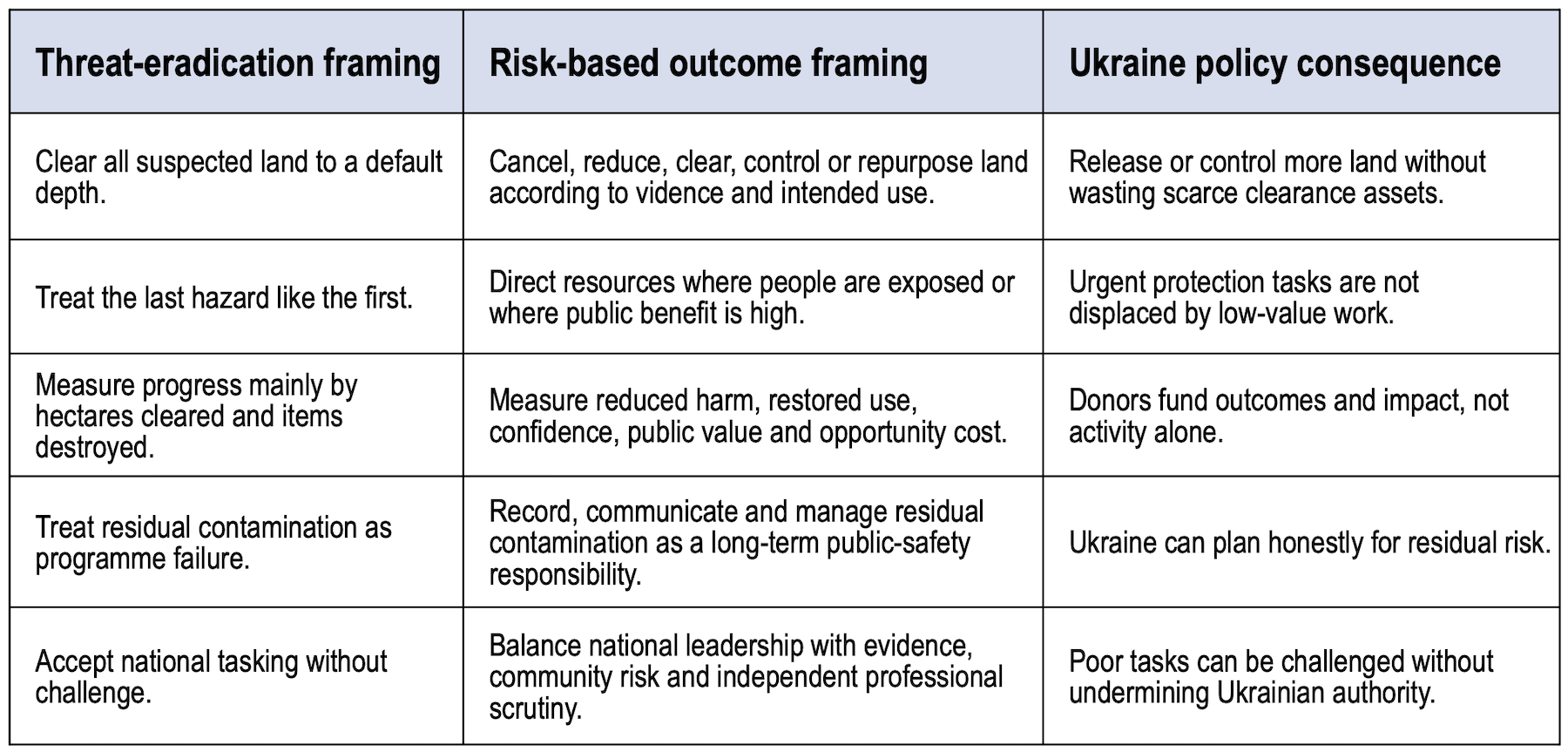
Table 3.
The model below is a deliberate expansion of the earlier red/amber/green/blue model. It is more Ukraine- specific because the country faces a vast area of land that may be suspected simply because it was occupied, crossed by forces, or located within a broad conflict area. Treating all such land as equal would inflate the problem and slow recovery. The model therefore separates land that is truly high-risk from land that is managed-risk, land with no evidence of mines after different levels of assessment, and land with no reason for suspicion. Blue is kept as an overlay for public-priority corridors rather than as a normal contamination category.
The model must be dynamic. New evidence, new technologies, changed frontlines, drone-delivered submunitions, delayed fuzes, cluster-type payloads, fire, flood, erosion and informal human use can all change classification. A red area today could become orange after a viable controlled-use proposal. An orange area could become green after targeted survey and clearance. A green area could require renewed warning or reassessment if new contamination appears.
This expanded classification system avoids three mistakes. First, it avoids pretending that heavily fought- over trench belts, shattered settlements and artillery- saturated defensive lines can be treated like ordinary farmland or normal infrastructure projects. Second, it avoids allowing broad suspicion to become a clearance obligation for land that has no evidence of contamination. Third, it recognises that exclusion and control may sometimes be the most responsible human-security response, especially where vulnerability cannot be reduced through marking, education, partial clearance or controlled use. It gives Ukraine a way to manage the worst land honestly while releasing or deprioritising land where the evidence does not support full intervention.
For Ukraine, the most obvious candidates for red or long-orange status will be heavily fought-over trench belts, former defensive lines, mined approaches, shattered settlements and artillery-saturated ground in parts of the east and south. Some of these areas may remain unsuitable for normal farming, housing or forestry for a decade or more after active fighting stops. That should be said plainly. Where informal entry cannot be prevented and vulnerability cannot be managed, exclusion, compensation and alternative support may protect people better than premature clearance promises.
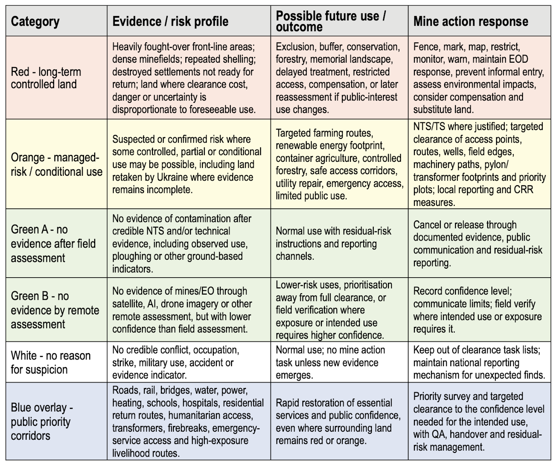
Table 4.
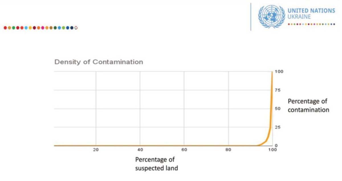
Figure 3. UN Ukraine discussion graphic: suspected land and contamination density are not evenly distributed. The policy implication is that most suspect land should not be treated as if it requires full clearance.
6. DATA-ENABLED PRIORITISATION AND THE OPTIMAL BALANCE BETWEEN RESOURCES AND RESULTS
The Ukrainian context makes data-enabled prioriti- sation unusually important.
A system such as Grit, an AI-enabled decision tool developed with Ukrainian and external technical support, reportedly draws on multiple data sources: hazard data, satellite imagery, agriculture, forestry, return, census, casualty, population, infrastructure and other datasets. If validated and governed properly, such tools could help classify land, test public-value assumptions and prioritise tasks at national scale.
Ukraine’s rapid wartime innovation in drones, sensors, autonomy and data integration should be treated as a strategic advantage for mine action, not only for the battlefield. Donor support could help Ukrainian companies, joint ventures and public institutions test, validate and scale mine action technologies under government oversight, with UN and donor involvement focused on transparency, standards compliance and public-value outcomes.
Such tools should not replace professional judgement or community evidence. Their value is to make the risk-based model operational: to ask which areas appear to have no evidence of mines, which areas are close to schools, power systems or high-use routes, which areas have repeated casualties, which land has high future value, and which tasks have weak evidence or low public benefit.
The same logic applies to methods. Satellite and AI assessment, drone imagery, non-technical survey, technical survey, machines, sensors, animal detection and manual clearance all sit on a cost-confidence curve. Each step can increase confidence, but usually at higher cost. The method should be chosen by the confidence level required for the intended future use, not by a default assumption that every suspect area must move toward the most expensive end of the curve.
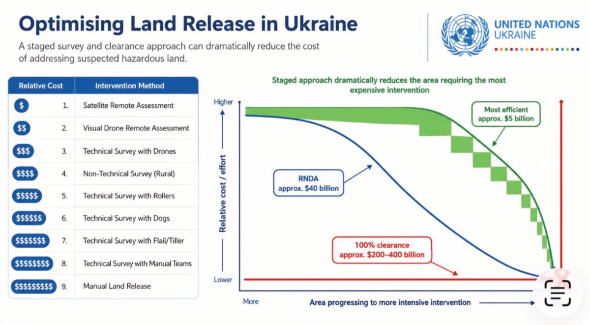
Figure 4. UN Ukraine discussion graphic: methods can be viewed on an efficiency curve, with confidence and cost increasing as the process moves from remote assessment toward manual clearance.
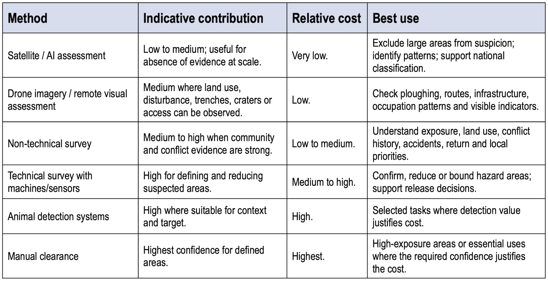
Table 5.
Efficiency principleThe question is not “which method is safest in the abstract?” but “what confidence level is needed for this intended use, and what is the least costly combination of evidence, survey, clearance and residual-risk controls that can reach a reasonable and acceptable end state?” |
Land classification should not be driven only by the current risk or by financial return. It should consider intended future land use, exposure, vulnerability and public value. Net present value (NPV) or discounted cash-flow analysis can help where a site has potential commercial or infrastructure use. But it should sit inside a wider human-security test that includes social value, cultural value, environmental management, public confidence, normalisation and stabilisation.
A site may be uneconomic if assessed only as pre- war agricultural land, but viable if repurposed for wind, solar, container-based production, controlled forestry, conservation, a memorial landscape or essential infrastructure. Conversely, a site may have high theoretical agricultural value but low immediate public value if it is remote, rarely used, highly contaminated and expensive to treat while communities elsewhere face immediate exposure. Economic analysis should help expose opportunity cost; it should not displace protection of the most at-risk people.
Experience from long-running mine action programmes shows that clearance is often weakly justified if the only benefit counted is agricultural output. In legacy contexts, agricultural gains can be modest, slow, or heavily dependent on other factors such as roads, irrigation, credit, inputs and markets. Mine action is usually better justified through human safety, dignity, freedom of movement, reduced fear, confidence, psychological security, and the removal of a binding constraint on wider recovery. This does not reject economic analysis. It simply places it inside a wider public-value, welfare and human- security framework.
Ukraine therefore needs two linked tests. The first is a financial or economic test where the land use is commercial or infrastructure-related. The second, and more fundamental, is a human-security and public-value test where the outcome is protection, return, social or cultural recovery, environmental management, public confidence or stabilisation.
Both tests should ask whether full clearance is necessary, whether partial clearance would unlock most of the benefit, whether a different future land use would produce greater public value, whether exclusion is the only credible risk-reduction measure, and whether compensation or substitute land would better protect people.
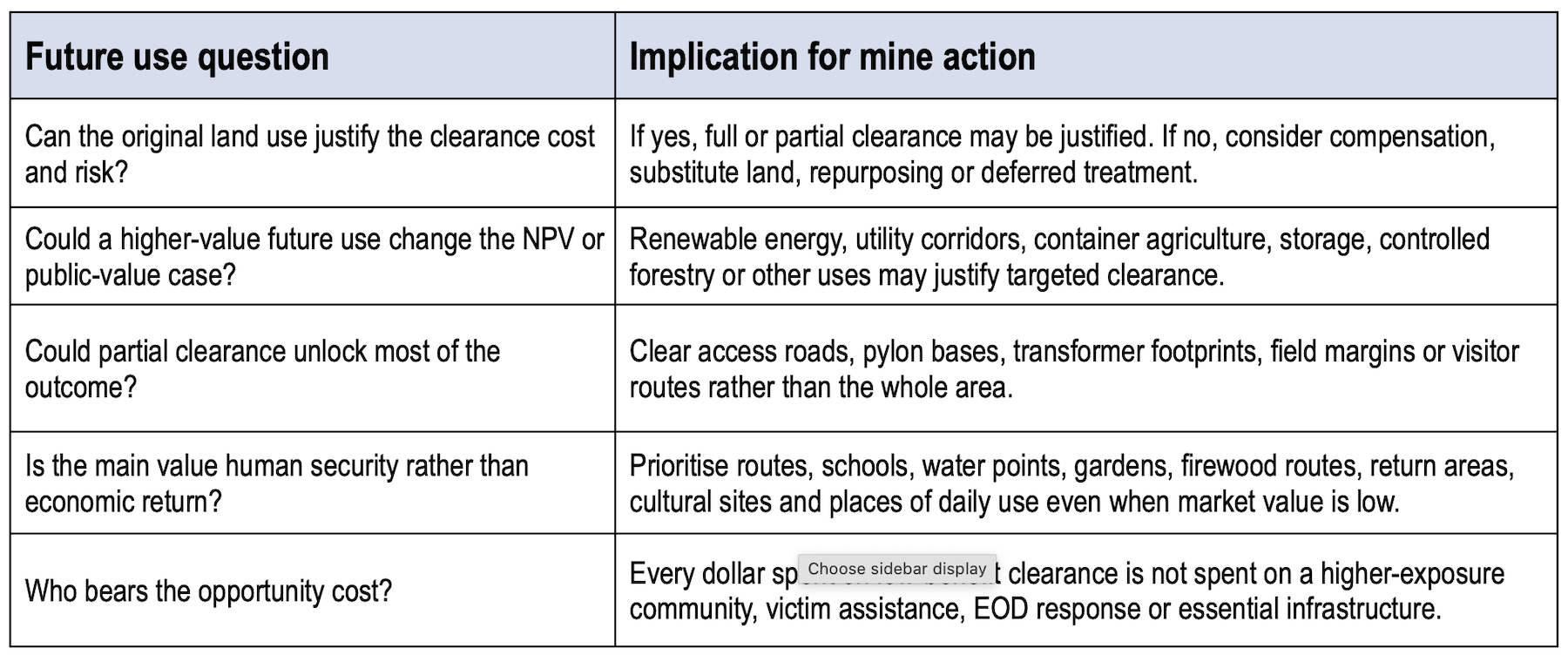
Table 6.
Renewable energy exampleA contaminated hillside may be uneconomic as agricultural land, but viable as a wind-energy site. The first task may not be full clearance of the entire hill. It may be targeted clearance of access routes, turbine bases, transformer locations and maintenance corridors. If the project generates revenue, later clearance or land management can be funded in phases. The land can move from red to orange and eventually to green for defined uses. |
Controlled-use exampleSome land may be unsuitable for normal agriculture because of chemical contamination or explosive risk, but could support container-based production or other sealed/controlled uses that do not draw from the soil. This does not make the land hazard-free. It changes exposure and therefore changes the risk-management option. |
Welfare principleWhere clearance does not produce strong financial returns, it may still produce high welfare value if it reduces real exposure, restores basic capabilities, supports return, reduces fear or enables normal life. Value for money should mean appropriate targeting within a humanitarian purpose, not only economic return. |
7. FARMLAND, COMPENSATION AND DIFFERENTIATED LAND USE
Farmland will remain one of the most politically visible mine action issues in Ukraine. Agriculture is central to livelihoods, exports, rural identity and national recovery, and farmers are at risk, especially when using tractors and other heavy equipment. But farmland should not be treated as a single category.
The phrase “clear agricultural land” can hide very different realities: a family garden beside a damaged home; a farm track used daily by tractors; a high- value orchard; a mined field next to a returning settlement; a remote low-value plot in a dense defensive belt; land already informally farmed; land that cannot be irrigated; land too close to continuing military risk; or land whose market value is far below the clearance cost.
For Ukraine, the question should not be “is this farmland contaminated?” but “what public value is created by restoring this land to this use, compared with the cost and risk of clearance and the alternatives available?” In some cases, full clearance will be clearly justified. In others, a better public decision may be compensation, substitute land, targeted access clearance, fencing, marking, monitoring and deferred treatment.
This should be presented carefully. It is not an argument that poor farmers should lose land because clearance is expensive. It is an argument that the farmer’s welfare should be the starting point. If public money can protect the person faster through compensation, substitute land, access corridors or targeted clearance, that may be a better humanitarian decision than leaving the person waiting years for a full- area clearance task that is unlikely to be funded soon.
Practical public-value testIf full clearance of a remote or low-value plot would cost several million dollars, while the land’s market or livelihood value is only a small fraction of that, the humane and economical answer may be to compensate the owner, provide access to substitute land, fence and mark the contaminated plot, and redirect clearance assets to places where people face immediate risk. This is not abandonment. It is a way of protecting the owner faster while also protecting other people whose roads, homes, schools, water points or machinery routes may be more urgent. |
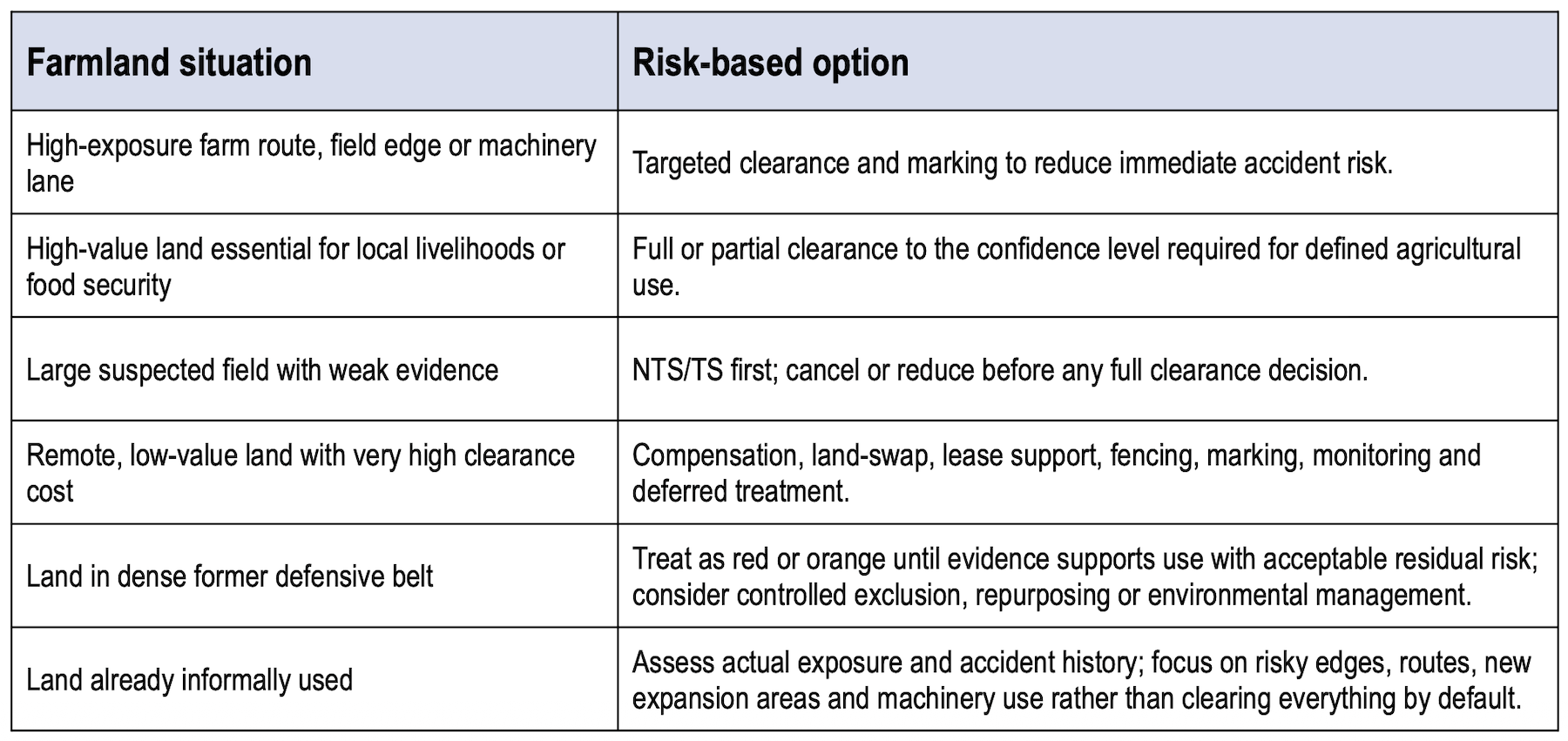
Table 7.
8. PUBLIC INFRASTRUCTURE, SOCIAL USE AND PARTIAL CLEARANCE FOR OUTCOMES
The strongest practical examples of outcome-led mine action are often not farmland examples. They are infrastructure, access and community-use examples. A power transformer, water system, school route, clinic access road, firebreak, cultural site, cemetery, market route, bridge or picnic area may have higher immediate public value than a large remote field.
If limited clearance allows ten damaged transformers to be replaced and power restored to 50,000 people, that may be a better outcome than fully clearing one transformer site and restoring power to 5,000 people. The technical task should be shaped by the outcome: access for repair, replacement and maintenance, with residual risk recorded and managed. That is not lower-quality mine action. It is more disciplined mine action.
Firebreaks and forestry access provide another example. Where indicators suggest low contamination probability, mechanical passes, visual inspection, remote assessment and targeted technical survey may provide a reasonable level of confidence for emergency-service access or forestry work, while full manual metal-free clearance is reserved for areas with triggered indicators or higher exposure.
Social and cultural uses also matter. Access to cemeteries, memorials, churches, community buildings, parks, lakes, forests, mushroom-picking areas and picnic sites may not produce high NPV, but may be central to normalisation, trust in local authorities, mental recovery and a sense that life can resume. These are human-security outcomes, not optional extras.
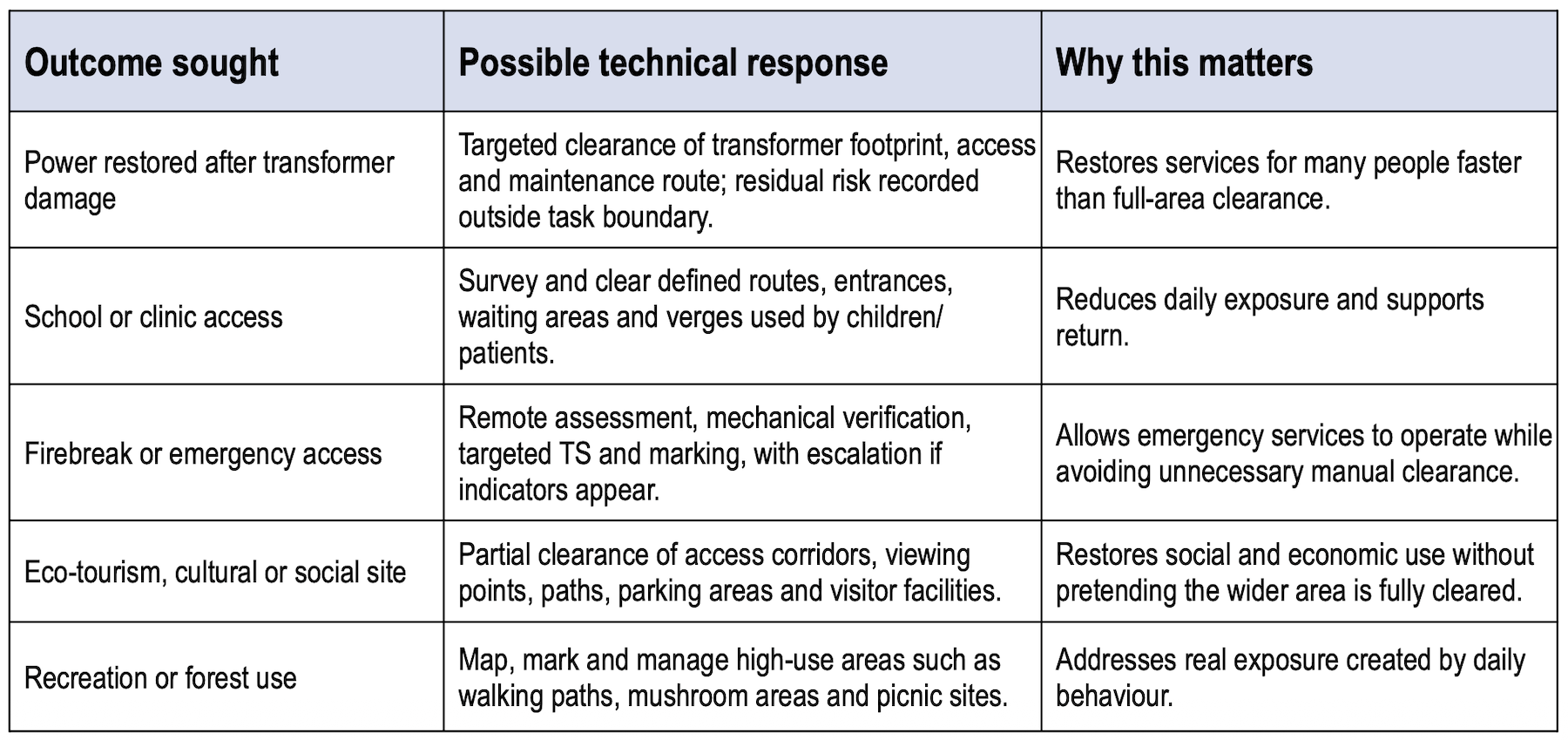
Table 8.
9. EVIDENCE-BASED LAND RELEASE AND ACCOUNTABLE JUDGEMENT
Experience from mature mine action programmes shows a common failure mode: technically impressive systems can become strategically inefficient. Large inherited polygons, rigid task lists, separated survey and clearance functions, and standards applied as fixed prescriptions can lead teams to process land because it is in the database, not because it reflects the current pattern of risk.
Ukraine has the chance to avoid mistakes that took decades to become visible elsewhere. It should not build a system that generates vast suspected or surveyed areas that sit in the database as obligations, waiting years for clearance. Survey should quickly lead to one of four decisions: cancel, reduce, clear for a defined use, or control/restrict with a clear residual-risk plan.
Teams should start from evidence points, conflict history, community information, accident data, military pattern analysis and intended land use, and update decisions as work proceeds. This is not loose discretion. It is accountable judgement. National standards should define default methods and documentation, but also allow justified deviations where default requirements are excessive, inappropriate or poorly matched to evidence.
Quality assurance should ask not only whether the template was followed, but whether the reasoning was sound and documented. A useful Ukrainian standard would allow an operator to say: this is the default standard, but the evidence shows that a different boundary, depth, tool mix or land-use control measure is more appropriate; here is the evidence; here is the reasoning; here is how residual risk will be managed.
Opportunity-cost and human-capital principle
A task can be technically valid and still be the wrong priority. In a system with limited survey, clearance and EOD capacity, applying resources to one area means not applying them to another. The choice should therefore be judged against the alternative use of the same capacity: would another task reduce greater risk, protect more exposed communities, restore more essential services, or support normalisation and recovery sooner? This is the difference between mindless and mindful land release – processing land because it sits in a database, rather than using evidence and judgement to decide where effort matters most.
The opportunity cost is also human. Survey, clearance and EOD personnel accept real cumulative risk whenever they are deployed. Even highly trained teams can be injured or killed through repeated exposure, equipment failure, environmental change or simple bad luck. Ukraine should not expose scarce technical personnel to tasks with limited outcome value while higher-risk communities wait. In red or long- orange areas with low immediate public benefit and controllable access, deferral may also be justified because safer automated, remote or robotic systems may become available over the coming years, reducing both cost and risk to clearance personnel.
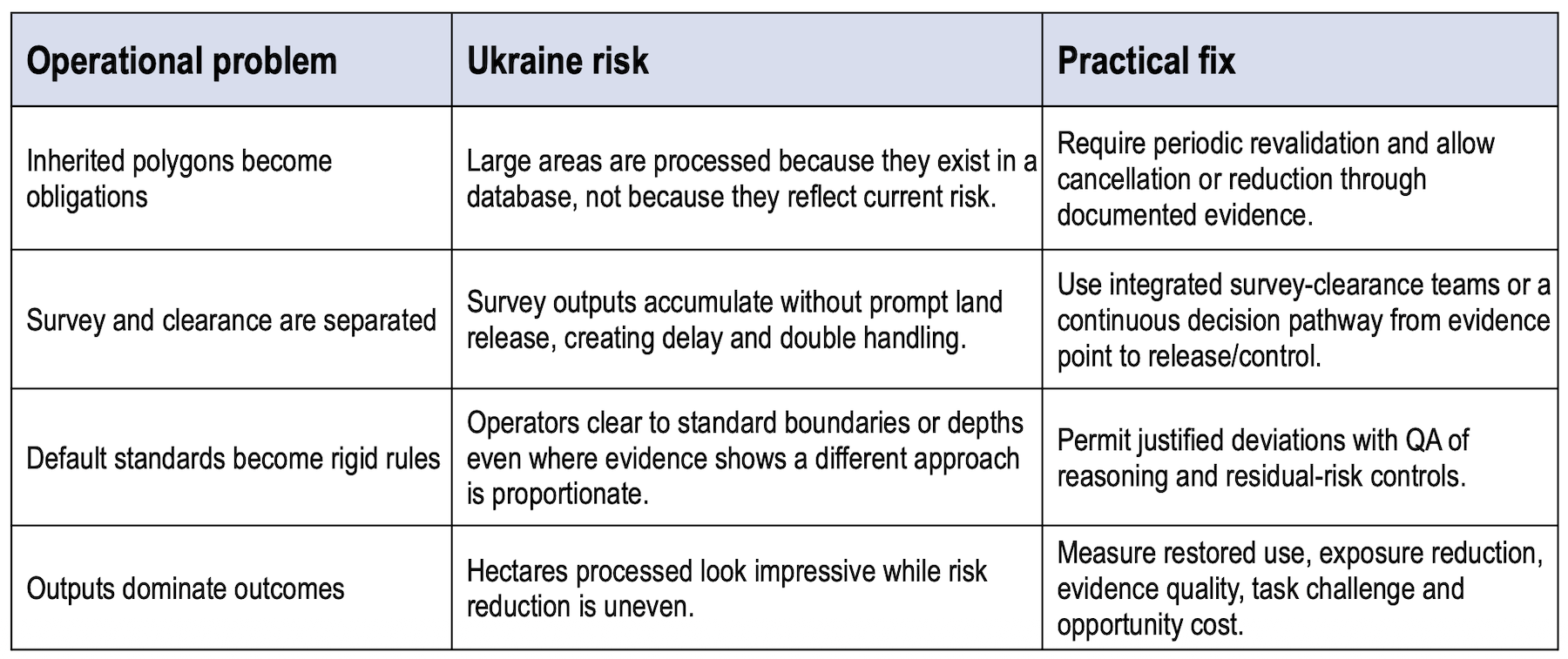
Table 9.
10. COMMUNITY RISK REDUCTION, EXPOSURE AND HUMAN SECURITY CRR
is the community layer of this model. It asks who is exposed, why they are exposed, what choices they have, and what practical measure would reduce exposure fastest. In Ukraine, exposure may be driven by return, farming, grazing, repairing utilities, clearing rubble, collecting firewood, walking dogs in woods, collecting mushrooms, picnicking, using informal tracks, visiting cemeteries, or restoring local services.
This helps correct the bias that can arise when prioritisation is driven mainly by macroeconomic value.
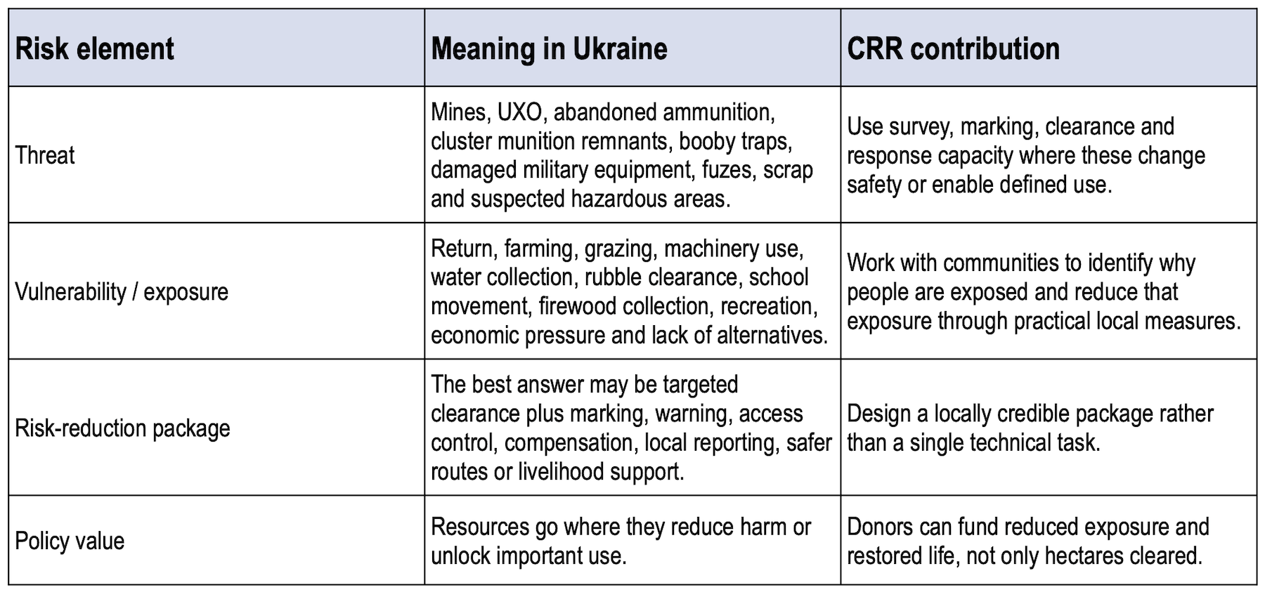
Table 10.
A small daily-use area may be more important for protection than a large remote field. Conversely, a large field may look economically attractive but expose few people if it is remote and alternatives exist. The test is not only what the land could earn, but who is exposed, what pressure pushes them into danger, and whether that vulnerability can be reduced.
Human security should therefore be understood broadly. It includes physical safety, but also confidence, movement, access to services, social life, dignity, recovery and local normalisation. Robust red- zone exclusion can be a human-security measure if it prevents people entering a dangerous area and is paired with compensation, alternative access, clear communication and response capacity. Partial release can also be a human-security measure if it allows essential services or social life to resume with acceptable residual risk.
In some areas, vulnerability cannot be reasonably reduced through zoning, marking, education, controlled access or livelihood support. This may be true for heavily contaminated trench belts, dense minefields near returning populations, land where informal use cannot be prevented, or areas affected by repeated recontamination. In those cases, the responsible response may be long-term exclusion and control, supported by compensation, substitute land, alternative livelihood support and permanent EOD response. This is not a failure of mine action. It is the honest application of the Zone Rouge lesson: protecting people sometimes means keeping them out.
11. GOVERNANCE, INCENTIVES AND DONOR DISCIPLINE
A risk-based Ukraine strategy will require political courage because it changes incentives. It asks national authorities, donors and operators to admit that not every suspect area deserves full clearance, that some land should be managed rather than cleared, that future use may be different from past use, and that weak tasks should be challenged before money is spent.
The political sensitivity of this approach should not be underestimated. Areas most likely to fall into red or long-orange categories may also be those that have suffered the greatest destruction, displacement and economic loss. A classification model must therefore avoid any impression that frontline communities are being written off or asked to accept a second-class recovery. Long-term control, exclusion or deferred treatment should be paired with visible state support: compensation, substitute land, livelihood assistance, infrastructure prioritisation where possible, clear communication, periodic review and a credible pathway for reclassification if conditions change. The message should be that the state is protecting people and making honest land-use decisions, not abandoning damaged regions.
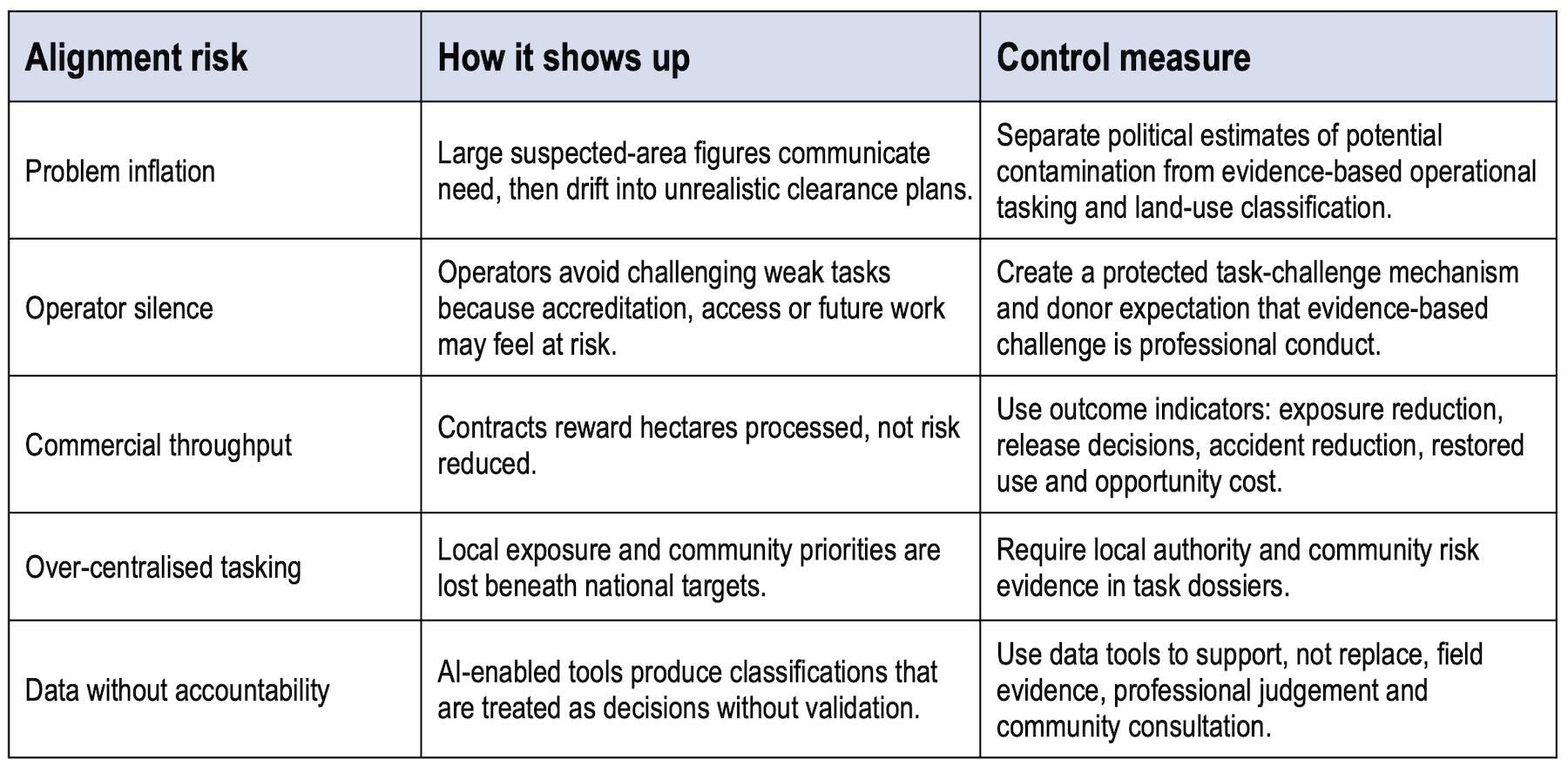
Table 11.
National ownership should be Ukrainian-led, but also evidence-led, community-aware and open to professional challenge. Operators should not be placed in a position where the safest institutional behaviour is to accept every task, process every polygon, and avoid difficult conversations. Donors should make task challenge a normal part of quality management.
Decisions to classify land as red or long-orange, or to exclude, repurpose or defer treatment, should be transparent, recorded and open to review. They should involve Ukrainian authorities, local government, land administration actors, affected communities and qualified mine action expertise. Each decision should state the evidence used, the intended or proposed land use, the residual-risk judgement, the support offered to affected owners or communities, and the conditions under which the classification can be reviewed or challenged.
This is especially important as Ukraine develops domestic commercial capacity. A national demining market can be valuable. It can create jobs, build sovereignty and reduce reliance on international NGOs. But market incentives need discipline. Payment systems, accreditation rules and donor contracts should not reward land processed for its own sake. They should reward well-evidenced risk reduction, restored use, rapid response where exposure is high, and honest cancellation or reduction where clearance is not needed.
12. FUNDING, RECOMMENDATIONS AND DECISION TEST
Ukraine will need very large and sustained support. But donors should fund the right things at the right time: survey, information management, local risk analysis, task scrutiny, quality assurance, compensation mechanisms, residual-risk response, community-level risk reduction and data-enabled prioritisation, not only clearance teams and machines.
Value for money should mean appropriate targeting. A task can be expensive and still be excellent value if it prevents deaths, enables return, restores essential infrastructure or removes a major constraint on livelihoods. A task can be cheap per square meter and still be poor value if it has low risk, low use, weak evidence or better alternatives.
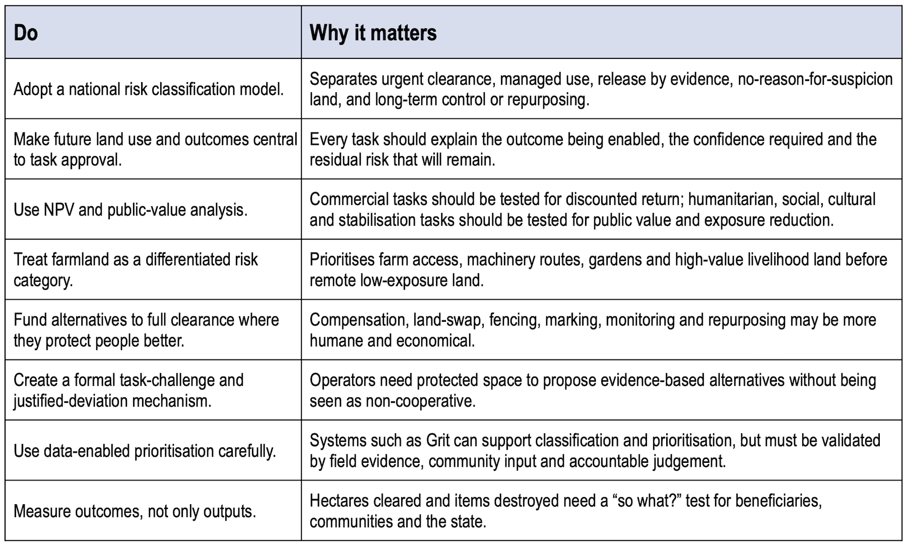
Table 12.
DONOR AND UN DECISION TEST
- Who is at risk, and during what activity?
- What future land use is being enabled, and is it the right use now?
- Is the proposed use the original use, or has a better post-war use emerged?
- What evidence supports clearance rather than cancellation, reduction, marking, fencing, compensation, land-swap, access control or repurposing?
- Does the task require full clearance, or would partial release achieve the outcome with acceptable residual risk?
- What is the public value of the outcome: human security, economic return, social/cultural recovery, infrastructure, environmental management or stabilisation?
- Who has authority to make the land-use decision, how has the evidence been documented, and what route exists for review or challenge if conditions change?
- If vulnerability cannot be adequately reduced through clearance, control, communication or support, is long-term exclusion with compensation and alternatives the most responsible human- security outcome?
- Could targeted clearance of routes, field margins, machinery lanes, wells, houses, transformers, firebreaks or infrastructure reduce risk faster than full-area clearance?
- What level of confidence is needed for the intended use, and what further effort would be unreasonable compared with the additional safety or development benefit?
- How will residual risk be recorded, communicated and managed after handover or release?
- Is this the best use of scarce technical capacity now, or would another task reduce greater risk, protect more exposed communities, restore more essential services, or support recovery sooner?
- Does the task justify the exposure of survey, clearance and EOD personnel, or could a safer combination of survey, control, marking, compensation, deferral or future technology achieve the same outcome?
- What is not being funded if this task goes ahead?
CONCLUSION
The Zone Rouge is not a model to copy mechanically. It is a warning and a useful policy example. Industrial war can leave contamination that outlives normal project cycles, donor strategies and political promises. France showed that a state can protect people without pretending that every hazard will be removed: classification, land-use control, reforestation, memorialisation, public warning, targeted clearance and permanent response capacity managed risk over more than a century.
Ukraine should take that lesson seriously. The comparison with First World War battlefields is visible in trenches, mine belts, artillery-saturated ground, destroyed settlements and uncertain contamination. In some places, full clearance will be necessary. It should not be the automatic answer everywhere. The automatic answer should be evidence, risk analysis and a clear decision about intended future land use.
The right goal is not a threat-eradication fantasy. The right goal is an outcome-led, risk-based land strategy: clear where needed, release land where evidence allows, control or exclude areas that cannot be used with acceptable residual risk, repurpose land where a better future use exists, compensate or support alternatives where clearance is disproportionate, and maintain capacity to deal with residual contamination.
This is not a retreat from mine action. It is mine action returning to its purpose: reducing the social, economic and human impact of explosive ordnance so people can live more safely and recover with confidence. Economic return, future land use and NPV matter, but they are not the centre of the argument. The centre is human security: protecting the most-at-risk people first, reducing vulnerability, and making honest decisions about land that cannot yet be made usable.
In Ukraine, the test of success should not be whether the country can promise to clear everything everywhere. It should be whether mine action helps people return, move, farm, work, repair infrastructure, rebuild communities, mourn, remember and live with a reasonable and acceptable level of residual risk. A strategy that excludes some land, repurposes other land, and clears the land that matters most for life and recovery is not less humanitarian. It is more honest, more protective, and more credible than over- promising full threat removal.
SELECTED SOURCES
- Mine Action Review, Clearing the Mines 2024: Ukraine: programme performance, reporting, prioritisation, disaggregation and evidence-based land release.
- UNDP, Enhancing Mine Action Finance in Ukraine: economic prioritisation, land release tasking, innovative finance and the possibility that some land may be better repurposed rather than returned to original use.
- Landmine Monitor Ukraine impact profile: reported potential contamination, population exposure and farmer/tractor casualty patterns.
- CSIS, Demining Ukraine’s Farmland: operational progress, capacity growth and the continuing challenge of returning agricultural land safely.
- ACAPS and Humanity & Inclusion reporting on Ukraine: the cross-sectoral role of mine action and the risk that daily-use areas such as gardens, water points, firewood routes, forest belts and local access routes can be missed if prioritisation is driven only by large agricultural land or economic value.
- 2018 EU IfS/IcSP mine action evaluation: historical background on short-term funding, national owner- ship and the need for credible technical advice. This source is treated as historical context only.
- UNDP Lao PDR UXO sector evaluation paper and mine action economics: welfare-economics limits of agricultural-output justification; value as human safety, dignity, freedom of movement, confidence, reduced fear, rights and appropriate targeting.
- Davies, Enhancing Mindfulness in Mine Action: Re-uniting Survey and Clearance to Maximise Impact: opportunity cost, mindful operators, standards that invite judgement, and the risk that procedurally compliant systems can become strategically inefficient when they process inherited polygons rather than current patterns of threat, exposure and community need.
- Operational experience from mature mine action programmes: re-uniting survey and clearance, evidence-point-driven approaches, standards that invite judgement, formal justified deviations and avoiding the tyranny of inherited polygons.
- AP Mine Ban Convention, International Mine Action Standards and public reporting on Ukraine’s 2025 suspension / withdrawal statements: legal and normative context. This paper does not provide a legal opinion on Ukraine’s treaty status.
- Limitations: This paper is a policy discussion paper, not an operational plan for Ukraine. It does not define exact Ukrainian red, orange, green, white or blue-overlay areas. That would require official data, security assessment, community consultation, environmental assessment, land administration analysis and government approval.■
ABOUT THE AUTHORS
Paul Davies is a mine action, evaluation and human security specialist with 30 years of experience in conflict-affected settings. He heads Mine Action and Monitoring and Evaluation at Human Security Solutions, leading reviews and advisory work. Paul began working in mine action in Asia in the early 1990s. He helped establish the Mines Advisory Group programme in Cambodia and Lao PDR, developed the ICRC’s initial mine risk education programme in Bosnia, advised UXO Lao, and more recently led the Swiss Foundation for Mine Action programme in Mindanao, Philippines, establishing a mini-MAC to strengthen coordination. In Cambodia, he designed a residual explosive ordnance risk- management system for infrastructure projects across more than 100 sites. He is co-author, with award-winning journalist Nic Dunlop, of War of the Mines: Cambodia, Landmines and the Impoverishment of a Nation, published in 1994 and endorsed by John Pilger and around 100 aid agencies. His evaluation work has included assignments for the EU, UNDP, UNICEF and The HALO Trust. Paul holds an MBA and History degree from the University of Cambridge. He is the father of five boys, and his only daughter, Lydia, is Chief of Staff at The HALO Trust: mine action now runs in the family! EUROPEAN LESSONS FOR OUTCOME-LED MINE ACTION paper does not provide a legal opinion on Ukraine’s treaty status. • Limitations: This paper is a policy discussion paper, not an operational plan for Ukraine. It does not define exact Ukrainian red, orange, green, white or blue-overlay areas. That would require official data, security assessment, community consultation, environmental assessment, land administration analysis and government approval.
Paul Heslop is an RCO Senior Mine Action Advisor and leads UNMAS operations in Ukraine, where he focuses on addressing the country’s severe contamination from mines and unexploded ordnance (UXO) caused by the ongoing war. He advises the UN Resident Coordinator and the UN Country Team in Ukraine, helping coordinate large-scale clearance efforts across one of the most heavily mined countries in the world. Heslop has highlighted the presence of around 6 million UXO items affecting roughly 20% of Ukraine’s territory and over 6 million people, with an estimated economic impact of $11 billion annually. A strong advocate for innovation, he promotes the use of drones, satellite imagery, AI, robotics, and sensors to improve detection and clearance of explosive hazards, especially as new types of advanced mines and remotely deployed devices continue to emerge. In 2026, Heslop has been a key speaker at International Mine Awareness Day (IMAD2026) events, where he has addressed global challenges in mine action, including both land and sea mines, and stressed the need for sustained investment and technological innovation to support recovery and reconstruction in conflict-affected regions.
Download PDF: 19-37 Paul Davies and Paul Heslop article – Zone Rouge to Ukraine – Counter-IED Report Autumn 2026
Counter-IED Report, Autumn 2026